HOVERMAP™

Access the Inaccessible
With Emesent Hovermap drones can do everything from assisting with search and rescue missions to taking aerial photographs and surveying areas. You can even use these helpful devices for mapping applications.
3D Pointshot can supply your business with Hovermap equipment from Emesent to provide a reliable autonomous scanning solution that enables you to map challenging or inaccessible areas. Mounting an Emesent Hovermap mobile mapping system to your drone allows you to collect data from the ground and the air and merge the results into a comprehensive set of valuable data.
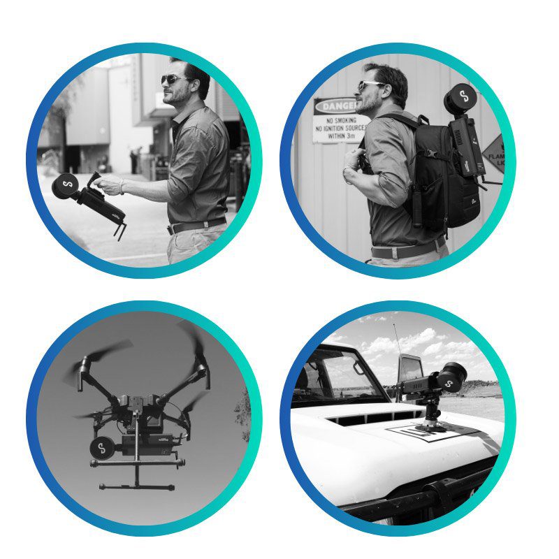
4-in-1 Versatility
Go from aerial scanning to mobile scanning in seconds.
- 1. Drone enabled
- 2. Vehicle mounted
- 3. Backpack mounted
- 4. Walking scans
Specifications
Mapping Specifications
| SLAM mapping | Simultaneous Localization and Mapping (SLAM) based LiDAR mapping +/- 0.03% drift |
|---|---|
| LiDAR range | 0.40 m to 100 m |
| LiDAR accuracy | +/- 30 mm |
| Mapping accuracy | +/- 20 mm in general environments +/- 15 mm in typical underground and indoor environments +/- 5 mm isolated change detection capability |
| Angular field of view | 360° x 290° |
| LiDAR data acquisition speed | Single Return Mode: up to 300,000 points/sec Dual Return Mode: up to 600,000 points/sec |
| Maximum data capture traveling speed | Vehicle: 40 km/h (24.9 mph); flight: 5 m/s (16.4 fps) above ground, 2 m/s (6.6 fps) underground or confined spaces |
| Start / stop scanning while walking or hovering | Yes |
| Outputs | Full resolution point cloud, decimated point cloud, trajectory file |
| Point cloud file format | las, .laz, .ply, .dxf, E57 |
| Point cloud attributes | Intensity, range, time, return number (strongest & last) and ring number |
| Processing parameters | Pre-set profiles with 20+ adjustable parameters |
| USB3 | High-speed data offload |
| Storage | 512 Gigabytes – approximately 8 hours of sensor data |
| Operating temperature | -10 to 45°C (14 to 113°F) |
Physical Specifications
| IP Rating | IP65 |
|---|---|
| Weight | 1.6 kg (3.63 lb) |
| Input voltage | 14 - 54V, powered from a battery or auxiliary power input |
| Deployment | Drone/UAV, backpack, vehicle, tether, ground robot |
| Supported drones | DJI M210v1, DJI M300, Acecore Zoe |
| Quick release mount | Yes |
| Auxiliary port | Proprietary connector |
| USB port | Yes |
| WiFI Antenna | Internal |
Autonomy Specifications
| Flight modes | Pilot Assist: Non-GPS flight, position hold, assisted flight, collision avoidance, regulated flight speed. Autonomous Waypoint Mode: Autonomous navigation to waypoints |
|---|---|
| AL2 waypoint types | 2D, 3D, planar, height |
| AL2 navigation modes | Guided exploration, local and global path planning |
| Autopilot compatibility | DJI, ArduPilot (Acecore Zoe) |
| Omnidirectional collision avoidance | 360° x 360°; size of an obstacle > 2 mm (5/64 “) wire; range 1.2 to 40 m (3.9 to 131 ft); In-flight adjustable safety distance |
| INCLUDED ACCESSORIES Handle, cables,case Universal mounting plate V-Mount 98Wh, 14.8v battery Standard battery charger Battery belt clip |
OPTIONS AND ACCESSORIES Colorization kit; Vehicle mounts; Protective cage; Hard case backpack ; Automated Ground Control targets; Cavity Monitoring System adaptor kit; Battery fast charger kit |